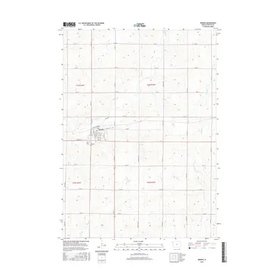
2015 Map of Remsen
USGS Topo · Published 2015About this map
The agricultural landscape of Plymouth County surrounds the town of Remsen, shown here in a 2015 study by the U.S. Geological Survey. The town's grid is clearly defined by local streets such as Franklin St, S Washington St, and Lincoln St, while the outskirts are marked by Saint Mary's Cem and Remsen Cem. The terrain is characterized by the gentle drainage patterns of Deep Cr to the north and Whisky Cr to the east, illustrating the typical Iowa prairie-and-creek geography. This survey provides a precise record of the road network, from the numbered township lines like 150th St to named corridors such as Celebrity Rd and Sunset Ave, capturing the enduring rural infrastructure of the region.
Find a feature on this map
40 named features on this map. Tap any name to fly to it.
Don’t see what you’re looking for? This feature index may not catch every label — zoom into the map to look around manually.
Map Details
Editions of this 2015 Remsen Map
This is the sole edition of this map. No revisions or reprints were ever made.
Other maps of this area

1954 · Fort Dodge
USGS Topo · 1:250,000

1955 · Sioux City
USGS Topo · 1:250,000

1957 · Fort Dodge
USGS Topo · 1:250,000

1958 · Sioux City
USGS Topo · 1:250,000

1958 · Fort Dodge
USGS Topo · 1:250,000

1959 · Sioux City
USGS Topo · 1:250,000

1962 · Le Mars
USGS Topo · 1:62,500

1962 · Union Center
USGS Topo · 1:62,500

1969 · Fielding
USGS Topo · 1:24,000
1969 · Granville West
USGS Topo · 1:24,000