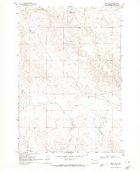
1969 Map of Reva NW
USGS Topo · Published 1971About this map
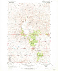
Big Two Top Butte and Little Two Top Butte dominate the northern horizon of this Harding County landscape, serving as prominent landmarks for the network of drainages that define the local geography. The area is characterized by a complex system of seasonal and perennial waterways, most notably the South Fork Grand River which meanders through the central portion of the sheet. This 1969 field-checked survey reveals a territory shaped by ranching and traditional land use, where family-named and descriptive features like Eggland Creek and Prairie Dog Creek mark the open range. Smaller tributaries such as Turtle Creek, Skull Creek, and Horse Creek converge toward the river valley, illustrating the natural drainage patterns of the western Dakotas. The map provides a precise record of the section lines, unimproved roads, and fence lines that partitioned this part of the plains in the late 1960s.
Find a feature on this map
12 named features on this map. Tap any name to fly to it.
Don’t see what you’re looking for? This feature index may not catch every label — zoom into the map to look around manually.
Map Details
Editions of this 1969 Reva NW Map
This is the sole edition of this map. No revisions or reprints were ever made.
Other maps of this area

1935 · Reva
USGS Topo · 1:125,000

1954 · Lemmon
USGS Topo · 1:250,000

1957 · Lemmon
USGS Topo · 1:250,000
1968 · Reva
USGS Topo · 1:24,000
1968 · Ralph SW
USGS Topo · 1:24,000
1968 · Ludlow SE
USGS Topo · 1:24,000

1968 · Ralph
USGS Topo · 1:24,000
1969 · Battleship Rock
USGS Topo · 1:24,000
1969 · Reva NE
USGS Topo · 1:24,000
1971 · Sheep Pen Draw
USGS Topo · 1:24,000