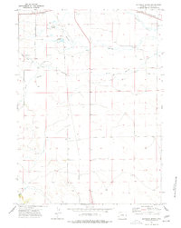
1974 Map of Reynolds Spring
USGS Topo · Published 1978About this map
Reynolds Spring and the surrounding high plains of Niobrara County come into focus during this mid-1970s survey. The landscape is defined by the drainage of the Niobrara River and Silver Springs Creek, reflecting a region tied to both its natural water sources and the infrastructure of the Chicago and North Western railroad corridor. The area shows a practical mix of ranching and early leisure, with Roadside Park and a Drive-in Theater positioned along the northern transport routes near the boundary of R 64 W and R 63 W.
Find a feature on this map
18 named features on this map. Tap any name to fly to it.
Don’t see what you’re looking for? This feature index may not catch every label — zoom into the map to look around manually.
Map Details
Editions of this 1974 Reynolds Spring Map
This is the sole edition of this map. No revisions or reprints were ever made.
Other maps of this area

1954 · Torrington
USGS Topo · 1:250,000

1958 · Torrington
USGS Topo · 1:250,000

1974 · Silver Springs
USGS Topo · 1:24,000

1974 · Rawhide Buttes East
USGS Topo · 1:24,000

1977 · Hileman Draw
USGS Topo · 1:24,000
1978 · Node
USGS Topo · 1:24,000
1978 · Rawhide Buttes West
USGS Topo · 1:24,000

1981 · Lusk
USGS Topo · 1:24,000
1981 · Signature Rock
USGS Topo · 1:24,000

1981 · Manville
USGS Topo · 1:24,000