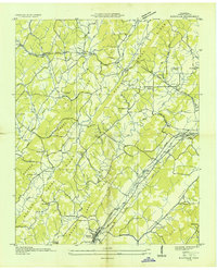
1935 Map of Riceville
USGS Topo · Published 1935About this map
Southern Railway tracks parallel the State Highway as they cut through the heart of McMinn County, defining the early 20th-century corridor between Riceville and Idlewild. This mid-1930s landscape is undergoing significant modernization, evidenced by the prominent Tennessee Valley Authority Transmission Line and a dedicated Landing Field near Moores Pond. Despite these industrial advances, the area remains deeply rooted in its rural network of country schools and churches, such as Rocky Mt Sch and Union Chapel.
Find a feature on this map
46 named features on this map. Tap any name to fly to it.
Don’t see what you’re looking for? This feature index may not catch every label — zoom into the map to look around manually.
Map Details
Editions of this 1935 Riceville Map
This is the sole edition of this map. No revisions or reprints were ever made.
Other maps of this area

1886 · Cleveland
USGS Topo · 1:125,000

1887 · Kingston
USGS Topo · 1:125,000

1891 · Kingston
USGS Topo · 1:125,000

1892 · Cleveland
USGS Topo · 1:125,000

1893 · Kingston
USGS Topo · 1:125,000

1895 · Cleveland
USGS Topo · 1:125,000

1901 · Cleveland
USGS Topo · 1:125,000

1935 · Niota
USGS Topo · 1:24,000

1935 · Calhoun
USGS Topo · 1:24,000

1935 · Athens
USGS Topo · 1:24,000