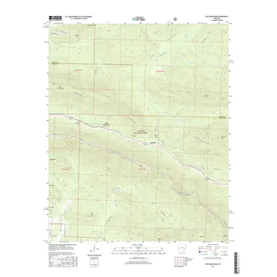
2017 Map of Rich Mountain
USGS Topo · Published 2017About this map
Ouachita National Forest dominates this landscape, where the ridge of Rich Mountain and Black Fork Mountain define the high terrain of the Ouachita Mountains along the border of Scott and Polk counties. The area is characterized by high-elevation roads like Skyline Dr and the long-distance Ouachita National Recreation Trail, which follows the spine of the ridges. Smaller settlements like Eagleton and the community of Rich Mountain sit in the lower valleys, connected by historic paths such as Ryder Rd and Broken Bridge Rd. For genealogists and local historians, the map identifies small burial sites including Sexton Cem and Little Cem. The drainage patterns are clearly visible, with the headwaters of the Ouachita River winding through the eastern portion of the quadrangle while various creeks like Big Cr and Powell Cr flow through the deep hollows between peaks like Pilot Mtn and Fourche Mtn.
Find a feature on this map
53 named features on this map. Tap any name to fly to it.
Don’t see what you’re looking for? This feature index may not catch every label — zoom into the map to look around manually.
Map Details
Editions of this 2017 Rich Mountain Map
This is the sole edition of this map. No revisions or reprints were ever made.
Other maps of this area

1879 · Poteau Mountain
USGS Topo · 1:62,500

1887 · Poteau Mountain #1
USGS Topo · 1:62,500

1887 · Poteau Mountain #2
USGS Topo · 1:62,500

1890 · Poteau Mountain
USGS Topo · 1:125,000

1899 · Poteau Mountain
USGS Topo · 1:125,000

1939 · Waldron
USGS Topo · 1:62,500

1940 · Waldron
USGS Topo · 1:62,500

1941 · Waldron
USGS Topo · 1:62,500

1949 · Waldron
USGS Topo · 1:62,500

1950 · Mcalester
USGS Topo · 1:250,000