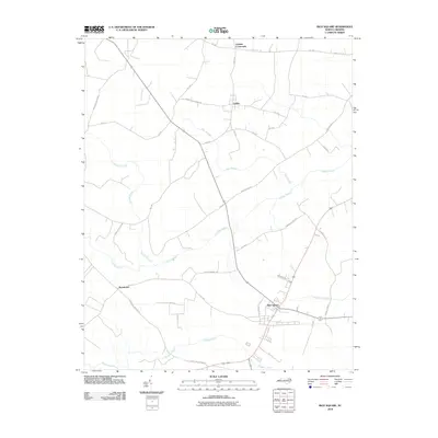
2010 Map of Rich Square
USGS Topo · Published 2010About this map
Rich Square and the surrounding agricultural lands of Northampton County are defined by an intricate network of slow-moving water and low-lying wetlands. The landscape is characterized by prominent features like Bear Swamp and Urahaw Swamp, which intersect the local road grid. Small settlements such as Lasker, Bryantown, and Lassiter Crossroads serve as focal points for the rural community, connected by routes such as Chapel Hill Church Rd and Pinners Church Rd. The drainage patterns of Bridgers Creek and Cutawhiskie Creek suggest a terrain that has long dictated the placement of farms and homesteads in this coastal plain region. The distribution of these named crossroads and secondary roads provides a clear picture of the area's twentieth-century rural development and local infrastructure.
Find a feature on this map
36 named features on this map. Tap any name to fly to it.
Don’t see what you’re looking for? This feature index may not catch every label — zoom into the map to look around manually.
Map Details
Editions of this 2010 Rich Square Map
This is the sole edition of this map. No revisions or reprints were ever made.
Other maps of this area

1953 · Norfolk
USGS Topo · 1:250,000

1962 · Scotland Neck
USGS Topo · 1:24,000

1962 · Norfleet
USGS Topo · 1:24,000
1973 · Conway
USGS Topo · 1:24,000

1973 · Kelford
USGS Topo · 1:24,000

1974 · Boones Crossroads
USGS Topo · 1:24,000

1974 · Rich Square
USGS Topo · 1:24,000
1974 · Jackson
USGS Topo · 1:24,000
1975 · Galatia
USGS Topo · 1:24,000

1977 · Woodland
USGS Topo · 1:24,000