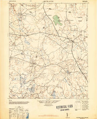
1948 Map of Richlands
USGS Topo · Published 1948About this map
Richlands stands as a central hub at the intersection of early North Carolina roads, surrounded by a landscape defined by the unique swampy basins of the coastal plain. The terrain is notably marked by the evocative Hell Pocosin and Purgatory Pocosin, dense evergreen shrub bogs that shaped the local settlement patterns and agriculture of Onslow and Duplin counties. These pocosin wetlands are drained by a network of waterways including Mill Swamp and the headwaters of the New River.
Find a feature on this map
38 named features on this map. Tap any name to fly to it.
Don’t see what you’re looking for? This feature index may not catch every label — zoom into the map to look around manually.
Map Details
Editions of this 1948 Richlands Map
2 editions found
Other maps of this area

1903 · Trent River
USGS Topo · 1:62,500

1904 · Trent River
USGS Topo · 1:62,500

1942 · Burgaw
USGS Topo · 1:62,500

1943 · Jacksonville
USGS Topo · 1:62,500

1943 · Kenansville
USGS Topo · 1:62,500

1948 · Kenansville
USGS Topo · 1:62,500

1948 · Maple Hill
USGS Topo · 1:62,500

1948 · New River
USGS Topo · 1:62,500

1948 · Richlands
USGS Topo · 1:62,500

1952 · Jacksonville South
USGS Topo · 1:24,000