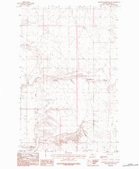
1984 Map of Richmond Reservoir SW
USGS Topo · Published 1984About this map
Chouteau Coulee carves through the landscape of Blaine County, Montana, defining the local drainage patterns as they were documented in the late 1970s. This agricultural and ranching terrain is characterized by its intermittent watercourses and the infrastructure required to manage them, notably the Twin Reservoir and Dry Fork Battle Creek. The map provides a clear look at the practical elements of the era's rural economy, including a prominent Pipeline corridor and clustered Storage Bins that likely served as collection points for local grain or supplies. This provisional survey captures the intersection of natural topography and human utility in a sparsely populated region where water management and resource storage are the primary markers of development.
Find a feature on this map
5 named features on this map. Tap any name to fly to it.
Don’t see what you’re looking for? This feature index may not catch every label — zoom into the map to look around manually.
Map Details
Editions of this 1984 Richmond Reservoir SW Map
This is the sole edition of this map. No revisions or reprints were ever made.
Other maps of this area

1904 · Yantic
USGS Topo · 1:62,500

1904 · Chinook
USGS Topo · 1:62,500

1912 · Zurich
USGS Topo · 1:125,000

1953 · Havre
USGS Topo · 1:250,000

1957 · Havre
USGS Topo · 1:250,000

1958 · Havre
USGS Topo · 1:250,000

1964 · Rabbit Hills
USGS Topo · 1:24,000

1964 · Telescope Coulee
USGS Topo · 1:24,000

1984 · Richmond Reservoir
USGS Topo · 1:24,000

1984 · Havre
USGS Topo · 1:100,000