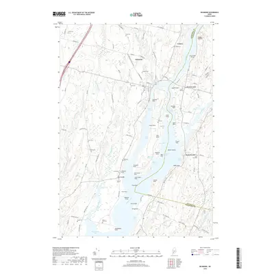
2018 Map of Richmond
USGS Topo · Published 2018About this map
The Kennebec River corridor dominates this coastal Maine landscape, splitting the terrain as it flows toward Merrymeeting Bay at the southern edge of the survey. The town of Richmond sits on the western bank, connected to the eastern shore at West Dresden via a prominent river crossing. A significant portion of the map is occupied by Swan Island, which sits in the center of the river and contains its own network of landmarks, including Swan Island Cem, Wade Pond, and Maxwell Cove.
Find a feature on this map
113 named features on this map. Tap any name to fly to it.
Don’t see what you’re looking for? This feature index may not catch every label — zoom into the map to look around manually.
Map Details
Editions of this 2018 Richmond Map
This is the sole edition of this map. No revisions or reprints were ever made.
Other maps of this area

1892 · Gardiner
USGS Topo · 1:62,500

1893 · Wiscasset
USGS Topo · 1:62,500

1893 · Boothbay
USGS Topo · 1:62,500

1894 · Bath
USGS Topo · 1:62,500

1920 · Bath
USGS Topo · 1:62,500

1941 · Boothbay
USGS Topo · 1:62,500

1943 · Gardiner
USGS Topo · 1:62,500

1943 · Boothbay
USGS Topo · 1:62,500

1944 · Wiscasset
USGS Topo · 1:62,500

1944 · Boothbay
USGS Topo · 1:62,500