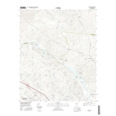
2017 Map of Richtex
USGS Topo · Published 2017About this map
The Broad River carves a winding path through the heart of this Piedmont landscape, separating Richland and Fairfield counties. The river corridor is defined by complex hydraulics and landforms, including Freshley Shoals, Bookman Shoals, and several large islands such as Haltiwanger Island and Hickory Island. Small communities like Richtex, Littleton, and Bookman are situated along the eastern banks, while the suburban growth of Irmo and Ballentine reaches toward the southern boundary near Lake Murray of Richland. Genealogists will find a high concentration of family-named burial sites across the rural northern sections, including Robinson Cem, Van Cem, and Gibson Cem. The area is interlaced with numerous tributaries like Hollinshead Creek and Little River, which dictated early road patterns and the placement of crossings such as Browns Bridge.
Find a feature on this map
138 named features on this map. Tap any name to fly to it.
Don’t see what you’re looking for? This feature index may not catch every label — zoom into the map to look around manually.
Map Details
Editions of this 2017 Richtex Map
This is the sole edition of this map. No revisions or reprints were ever made.
Other maps of this area

1904 · Columbia
USGS Topo · 1:125,000

1941 · Spartanburg
USGS Topo · 1:250,000

1946 · Irmo
USGS Topo · 1:24,000

1947 · Columbia North
USGS Topo · 1:24,000

1947 · Richtex
USGS Topo · 1:24,000

1948 · Irmo
USGS Topo · 1:24,000

1948 · Columbia North
USGS Topo · 1:24,000

1949 · Richtex
USGS Topo · 1:24,000

1949 · Irmo NE
USGS Topo · 1:24,000

1953 · Spartanburg
USGS Topo · 1:250,000