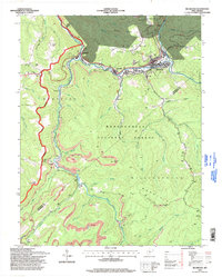
1995 Map of Richwood
USGS Topo · Published 1998About this map
The Cherry River valley serves as the industrial and social spine of this West Virginia landscape, where the lumber and coal town of Richwood sits at the confluence of the North and South Forks. By the mid-1990s, the terrain shows a complex layer of land use, from the deep timber of the Monongahela National Forest to active and former strip mines that mark the ridges of Williamsburg Mountain. Smaller settlements like Fenwick and La Frank cluster along the riverbanks, while isolated mountain communities and family landmarks are preserved in the back country. Genealogists can find numerous rural markers, including New Hope Ch, the Baber Cem, and Namo Chapel near Mill Ford. The topography is defined by high peaks like Mann Knob and Tanner Knob, overlooking a network of deep runs and hollows that historically dictated the placement of roads and rail lines.
Find a feature on this map
64 named features on this map. Tap any name to fly to it.
Don’t see what you’re looking for? This feature index may not catch every label — zoom into the map to look around manually.
Map Details
Editions of this 1995 Richwood Map
This is the sole edition of this map. No revisions or reprints were ever made.
Other maps of this area

1889 · Nicholas
USGS Topo · 1:125,000

1891 · Nicholas
USGS Topo · 1:125,000

1891 · Huntersville
USGS Topo · 1:125,000

1894 · Huntersville
USGS Topo · 1:125,000

1901 · Nicholas
USGS Topo · 1:125,000

1915 · Webster Springs
USGS Topo · 1:48,000

1915 · Cowen
USGS Topo · 1:48,000

1917 · Cowen
USGS Topo · 1:62,500

1918 · Webster Springs
USGS Topo · 1:62,500

1918 · Richwood
USGS Topo · 1:62,500