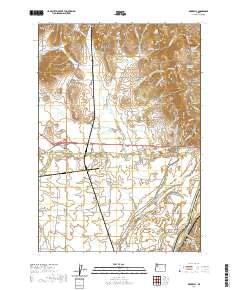
2020 Map of Rickreall
USGS Topo · Published 2020About this map
Rickreall stands as the central hub of this valley landscape, situated where the waters of Rickreall Cr flow toward the eastern boundary. The terrain is defined by the prominent Eola Hills and the southern reach of the Salem Hills, creating a natural corridor that has long guided regional travel and agriculture. Water management is a defining characteristic of the area, evidenced by numerous named reservoirs and ponds such as Parks Lake Reservoir, Ross Reservoir, and Stevens Reservoir, alongside the meandering paths of Baskett Slough and Mud Slough. These features indicate a sophisticated irrigation and drainage network supporting the local farmland. In the eastern portion, the Willamette River forms a significant geographical border near Hayden Lake and Humbug Lake. For those researching local heritage, the presence of the Etna Cem and Restlawn Memory Gardens provides specific points of interest for genealogical study.
Find a feature on this map
83 named features on this map. Tap any name to fly to it.
Don’t see what you’re looking for? This feature index may not catch every label — zoom into the map to look around manually.
Map Details
Editions of this 2020 Rickreall Map
This is the sole edition of this map. No revisions or reprints were ever made.
Other maps of this area

1914 · Independence
USGS Topo · 1:31,680

1915 · Rickreall
USGS Topo · 1:31,680

1915 · Eola
USGS Topo · 1:31,680

1915 · Sidney
USGS Topo · 1:31,680

1917 · Salem
USGS Topo · 1:62,500

1922 · Airlie
USGS Topo · 1:31,680

1924 · Mc Minnville
USGS Topo · 1:48,000

1926 · Mc Minnville
USGS Topo · 1:62,500

1940 · McMinnville
USGS Topo · 1:62,500

1940 · Salem
USGS Topo · 1:62,500