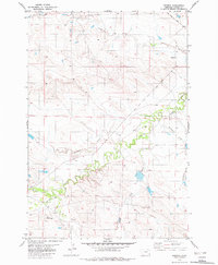
1982 Map of Ridgway
USGS Topo · Published 1982About this map
Ridgway sits as a quiet focal point in this southeastern Montana landscape, captured during a 1982 update of 1970s field data. The area is defined by a dendritic network of drainages including Boxelder Creek, Hawksnest Creek, and Whitetail Creek, which cut through the undulating terrain of Carter County. This map documents a ranching-centric economy, evidenced by the numerous marked wells and a remote Landing Strip near the confluence of Boxelder Creek and Muskrat Creek. The layout of roads and the single prominent Trail suggest a landscape where transportation follows the natural contours of the stream valleys and ridges. Genealogists and local historians can trace the specific water-rights and land-use patterns of the late twentieth century through the placement of isolated infrastructure across the Corral Creek and Sherril Creek basins.
Find a feature on this map
10 named features on this map. Tap any name to fly to it.
Don’t see what you’re looking for? This feature index may not catch every label — zoom into the map to look around manually.
Map Details
Editions of this 1982 Ridgway Map
This is the sole edition of this map. No revisions or reprints were ever made.
Other maps of this area

1954 · Ekalaka
USGS Topo · 1:250,000

1956 · Ekalaka
USGS Topo · 1:250,000

1958 · Ekalaka
USGS Topo · 1:250,000

1965 · Ekalaka
USGS Topo · 1:250,000

1979 · Dutchman Creek
USGS Topo · 1:24,000

1979 · Ikey Creek
USGS Topo · 1:24,000

1980 · Prairie Dog Creek
USGS Topo · 1:24,000
1980 · School Section Creek
USGS Topo · 1:24,000
1980 · Finger Buttes West
USGS Topo · 1:24,000

1981 · Alzada
USGS Topo · 1:100,000