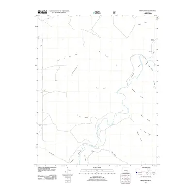
2011 Map of Riley Canyon
USGS Topo · Published 2011About this map
The Purgatoire River carves a deep path through Otero County in this 2011 survey, winding through a landscape dominated by complex drainage systems and isolated cattle-ranching infrastructure. The canyon lands are defined by high-walled tributaries such as Riley Canyon, Penitenta Canyon, and Gaussion Canyon, which feed into the larger river valley. For local historians and genealogists, the map preserves the locations of two distinct burial grounds, the Martinez Cemetery and San Jose Cemetery, situated near the floor of the Ninemile Valley. The reliance on groundwater in this arid terrain is evidenced by several named landmarks, including the Girard Windmill and Little Windmill along the western plateau. Transport into the rugged canyon floors is facilitated by routes like Rourke Rd and County Rd 804, which provide access to the remote Withers Canyon and Purgatoire Canyon reaches.
Find a feature on this map
29 named features on this map. Tap any name to fly to it.
Don’t see what you’re looking for? This feature index may not catch every label — zoom into the map to look around manually.
Map Details
Editions of this 2011 Riley Canyon Map
This is the sole edition of this map. No revisions or reprints were ever made.
Other maps of this area

1891 · Higbee
USGS Topo · 1:125,000

1891 · Timpas
USGS Topo · 1:125,000

1893 · Higbee
USGS Topo · 1:125,000

1894 · Timpas
USGS Topo · 1:125,000

1955 · La Junta
USGS Topo · 1:250,000

1958 · La Junta
USGS Topo · 1:250,000

1965 · La Junta SW
USGS Topo · 1:24,000

1966 · La Junta SE
USGS Topo · 1:24,000
1966 · Higbee
USGS Topo · 1:24,000

1968 · La Junta
USGS Topo · 1:250,000