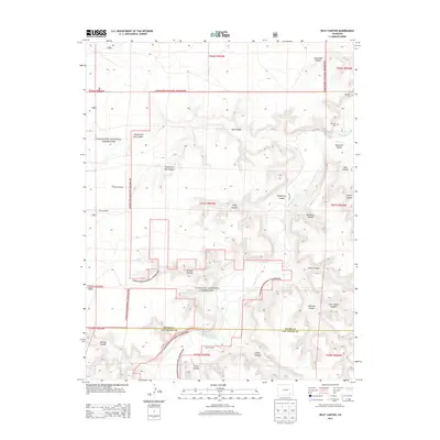
2013 Map of Riley Canyon
USGS Topo · Published 2013About this map
The Purgatoire River carves a deep path through the southeastern Colorado high plains, defining the topography of the Comanche National Grassland. This 2013 survey illustrates a landscape where water management is the primary driver of human activity, from the Ninemile Canal in Ninemile Valley to isolated water sources like Good Pasture Spring and the Rock Waterhole. Evidence of long-standing family ranching and settlement persists through the presence of the Martinez Cem and San Jose Cem near the river's edge. The complex network of drainages, including Riley Canyon, Jack Canyon, and Penitenta Canyon, creates a labyrinthine terrain. Scattered throughout the grassland, several landmarks such as the Girard Windmill and Little Windmill mark the essential points of access to groundwater in this arid environment.
Find a feature on this map
39 named features on this map. Tap any name to fly to it.
Don’t see what you’re looking for? This feature index may not catch every label — zoom into the map to look around manually.
Map Details
Editions of this 2013 Riley Canyon Map
This is the sole edition of this map. No revisions or reprints were ever made.
Other maps of this area

1891 · Higbee
USGS Topo · 1:125,000

1891 · Timpas
USGS Topo · 1:125,000

1893 · Higbee
USGS Topo · 1:125,000

1894 · Timpas
USGS Topo · 1:125,000

1955 · La Junta
USGS Topo · 1:250,000

1958 · La Junta
USGS Topo · 1:250,000

1965 · La Junta SW
USGS Topo · 1:24,000

1966 · La Junta SE
USGS Topo · 1:24,000
1966 · Higbee
USGS Topo · 1:24,000

1968 · La Junta
USGS Topo · 1:250,000