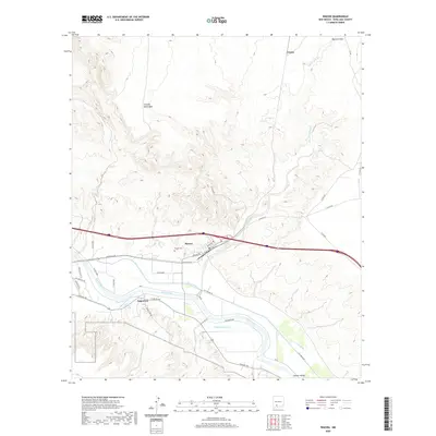
2020 Map of Rincon
USGS Topo · Published 2020About this map
Rincon sits at a geographic pivot point where the Rio Grande corridor meets the high desert of the Caballo Mountains. This map documents a landscape defined by water management and transit, where the Rincon Canal and Angostura Drain represent a complex irrigation system essential for the agricultural life of the Rincon Valley. The settlement pattern follows the river and the historic rail corridor, with the small community of Angostura located near the riverbank and the Rincon Cem and post office marking the social center of the area.
Find a feature on this map
41 named features on this map. Tap any name to fly to it.
Don’t see what you’re looking for? This feature index may not catch every label — zoom into the map to look around manually.
Map Details
Editions of this 2020 Rincon Map
This is the sole edition of this map. No revisions or reprints were ever made.
Other maps of this area

1916 · Tonuco
USGS Topo · 1:125,000

1932 · Tonuco
USGS Topo · 1:125,000

1948 · Chicken Well
USGS Topo · 1:62,500

1948 · San Diego Mountain
USGS Topo · 1:62,500

1955 · Las Cruces
USGS Topo · 1:250,000

1958 · Las Cruces
USGS Topo · 1:250,000

1959 · Hatch
USGS Topo · 1:24,000
1959 · Sierra Alta
USGS Topo · 1:24,000
1959 · Souse Springs
USGS Topo · 1:24,000

1959 · Rincon
USGS Topo · 1:24,000