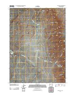
2011 Map of Rincon Flat
USGS Topo · Published 2011About this map
Rincon Flat dominates this high-desert landscape in southeastern Oregon, where water management defines the human footprint. This 2011 survey reveals a network of vital water sources and drainage patterns essential for ranching and survival in the Great Basin environment. Small-scale infrastructure is visible in the form of Box Canyon Reservoir and Dip Spring Reservoir, which capture seasonal flows from Long Hollow Creek and Dip Creek. The terrain is punctuated by significant landmarks like Domingo Pass and the deep incision of Box Canyon. Numerous named springs, including Desert Bog Spring, Deer Spring, and Bronco Spring, indicate the historical importance of localized water points for movement across this arid territory.
Find a feature on this map
15 named features on this map. Tap any name to fly to it.
Don’t see what you’re looking for? This feature index may not catch every label — zoom into the map to look around manually.
Map Details
Editions of this 2011 Rincon Flat Map
This is the sole edition of this map. No revisions or reprints were ever made.
Other maps of this area

1955 · Adel
USGS Topo · 1:250,000

1957 · Adel
USGS Topo · 1:250,000

1958 · Adel
USGS Topo · 1:250,000

1962 · Adel
USGS Topo · 1:250,000

1971 · Square Mountain
USGS Topo · 1:24,000

1971 · Fields Basin
USGS Topo · 1:24,000

1971 · Fields
USGS Topo · 1:24,000
1981 · Robbers Roost
USGS Topo · 1:24,000
1981 · Van Horn Basin
USGS Topo · 1:24,000
1981 · Ladycomb Peak
USGS Topo · 1:24,000