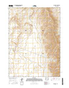
2017 Map of Rincon Flat
USGS Topo · Published 2017About this map
The Pueblo Mountains dominate the eastern landscape of this Harney County quadrangle, where the high desert terrain descends into the expansive Rincon Flat. This high-altitude basin is defined by a sparse but critical network of water sources, including the ephemeral Rincon Cr and several livestock or wildlife catchments like McDade Reservoir and Dip Spring Reservoir. The presence of numerous named springs, such as Bear Dog Spring and Desert Bog Spring, highlights the historical importance of water management in this arid stretch of southeastern Oregon.
Find a feature on this map
23 named features on this map. Tap any name to fly to it.
Don’t see what you’re looking for? This feature index may not catch every label — zoom into the map to look around manually.
Map Details
Editions of this 2017 Rincon Flat Map
This is the sole edition of this map. No revisions or reprints were ever made.
Other maps of this area

1955 · Adel
USGS Topo · 1:250,000

1957 · Adel
USGS Topo · 1:250,000

1958 · Adel
USGS Topo · 1:250,000

1962 · Adel
USGS Topo · 1:250,000

1971 · Square Mountain
USGS Topo · 1:24,000

1971 · Fields Basin
USGS Topo · 1:24,000

1971 · Fields
USGS Topo · 1:24,000
1981 · Robbers Roost
USGS Topo · 1:24,000
1981 · Van Horn Basin
USGS Topo · 1:24,000
1981 · Ladycomb Peak
USGS Topo · 1:24,000