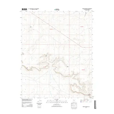
2013 Map of Rincon Marquez
USGS Topo · Published 2013About this map
Rincon Marquez sits within a complex system of high-desert drainages and plateau formations in the Eastern Navajo Agency. This 2013 topographic survey documents a landscape defined by sharp elevation changes, where the high ground of Chaco Mesa drops into the deep, winding Noberto Sandoval Cañon. The settlement pattern is sparse, centered on points like the Elkins Star Lake Ranch and the small community of Rincon Marquez. Water management and natural drainage are central to the geography here, evidenced by the named watercourses such as Rincon Marquez Arroyo, Vicente Arroyo, and Daniel Wash. These intermittent streams cut through the terrain, dictating the placement of primitive roads and established routes like Indian Service Route 47. The map provides a clear record of land management divisions, showing the grid of Township and Range boundaries including t19n r6w and t18n r5w that overlay this traditional territory.
Find a feature on this map
13 named features on this map. Tap any name to fly to it.
Don’t see what you’re looking for? This feature index may not catch every label — zoom into the map to look around manually.
Map Details
Editions of this 2013 Rincon Marquez Map
This is the sole edition of this map. No revisions or reprints were ever made.
Other maps of this area

1883 · Mt. Taylor
USGS Topo · 1:250,000

1886 · Mt. Taylor
USGS Topo · 1:250,000

1892 · Mt. Taylor
USGS Topo · 1:250,000

1899 · Mt. Taylor
USGS Topo · 1:250,000

1958 · Albuquerque
USGS Topo · 1:250,000

1960 · Pueblo Alto Trading Post
USGS Topo · 1:24,000
1961 · Ojo Encino Mesa
USGS Topo · 1:24,000
1961 · Star Lake
USGS Topo · 1:24,000

1961 · Whitehorse Rincon
USGS Topo · 1:24,000

1961 · Mesita Del Gavilan
USGS Topo · 1:24,000