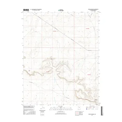
2017 Map of Rincon Marquez
USGS Topo · Published 2017About this map
Rincon Marquez sits as a primary point of reference in this high-desert landscape of New Mexico, where the terrain is defined by the significant rise of Chaco Mesa. The map captures a complex system of drainage and erosion, marked by the deep Noberto Sandoval Cañon and the winding paths of Rincon Marquez Arroyo and Vicente Arroyo. These natural features dictate the flow of travel through the region, seen in the alignment of Indian Svc Rte 9 and Rincon Marquez Rd. The geography here illustrates the remote nature of the Eastern Navajo Agency, where seasonal watercourses like Daniel Wash and established routes like Star Lake Rd provide the essential framework for navigation and land use in a region characterized by dramatic elevation changes and mesa formations.
Find a feature on this map
15 named features on this map. Tap any name to fly to it.
Don’t see what you’re looking for? This feature index may not catch every label — zoom into the map to look around manually.
Map Details
Editions of this 2017 Rincon Marquez Map
This is the sole edition of this map. No revisions or reprints were ever made.
Other maps of this area

1883 · Mt. Taylor
USGS Topo · 1:250,000

1886 · Mt. Taylor
USGS Topo · 1:250,000

1892 · Mt. Taylor
USGS Topo · 1:250,000

1899 · Mt. Taylor
USGS Topo · 1:250,000

1958 · Albuquerque
USGS Topo · 1:250,000

1960 · Pueblo Alto Trading Post
USGS Topo · 1:24,000
1961 · Ojo Encino Mesa
USGS Topo · 1:24,000
1961 · Star Lake
USGS Topo · 1:24,000

1961 · Whitehorse Rincon
USGS Topo · 1:24,000

1961 · Mesita Del Gavilan
USGS Topo · 1:24,000