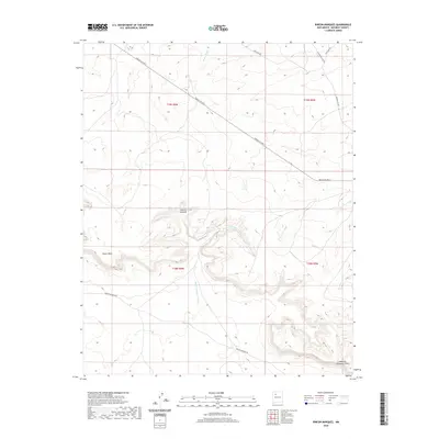
2020 Map of Rincon Marquez
USGS Topo · Published 2020About this map
Rincon Marquez sits within a landscape defined by the high elevations of Chaco Mesa and deep drainage systems in McKinley County. This high-desert terrain is carved by the Rincon Marquez Arroyo and Vicente Arroyo, which move water toward the northwest through a series of rugged canyons and washes like Daniel Wash. The settlement and surrounding rangeland are accessed via a network of service roads and local tracks, including the prominent Indian Svc Rte 9 which cuts diagonally across the northern townships. To the southeast, the terrain drops into Noberto Sandoval Cañon, illustrating the dramatic relief of the Eastern Navajo Agency. This 2020 survey documents the intersection of essential watercourses and traditional travel routes such as Rincon Marquez Rd and Star Lake Rd, providing a clear picture of the modern road network across this section of the Colorado Plateau.
Find a feature on this map
15 named features on this map. Tap any name to fly to it.
Don’t see what you’re looking for? This feature index may not catch every label — zoom into the map to look around manually.
Map Details
Editions of this 2020 Rincon Marquez Map
This is the sole edition of this map. No revisions or reprints were ever made.
Other maps of this area

1883 · Mt. Taylor
USGS Topo · 1:250,000

1886 · Mt. Taylor
USGS Topo · 1:250,000

1892 · Mt. Taylor
USGS Topo · 1:250,000

1899 · Mt. Taylor
USGS Topo · 1:250,000

1958 · Albuquerque
USGS Topo · 1:250,000

1960 · Pueblo Alto Trading Post
USGS Topo · 1:24,000
1961 · Ojo Encino Mesa
USGS Topo · 1:24,000
1961 · Star Lake
USGS Topo · 1:24,000

1961 · Whitehorse Rincon
USGS Topo · 1:24,000

1961 · Mesita Del Gavilan
USGS Topo · 1:24,000