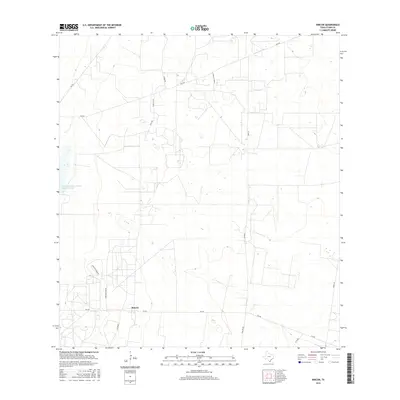
2016 Map of Rincon
USGS Topo · Published 2016About this map
The settlement of Rincon serves as a focal point in this south Texas landscape, characterized by ranching operations and water management infrastructure. The presence of the Soil Conservation Service Site 4 Reservoir highlights the importance of water storage in this semi-arid environment, while the Santa Fe Ranch and Starr Feedyard Rd indicate the regional reliance on livestock and agricultural industry. The area is intersected by a network of farm-to-market roads, including Fm 490, Fm 755, and Fm 2294, which facilitate movement between rural properties and larger regional hubs. Local thoroughfares such as Clerks Rd, Mariscos Ln, and Rivas Rd provide access to the various interior ranch lands and homesteads that define the community's footprint in Starr County.
Find a feature on this map
16 named features on this map. Tap any name to fly to it.
Don’t see what you’re looking for? This feature index may not catch every label — zoom into the map to look around manually.
Map Details
Editions of this 2016 Rincon Map
This is the sole edition of this map. No revisions or reprints were ever made.
Other maps of this area

1938 · Sal Colorada
USGS Topo · 1:62,500

1939 · La Reforma
USGS Topo · 1:62,500

1940 · Monte Christo
USGS Topo · 1:62,500

1949 · Mc Allen
USGS Topo · 1:250,000

1954 · McAllen
USGS Topo · 1:250,000

1956 · Garcias
USGS Topo · 1:62,500

1957 · Mc Allen
USGS Topo · 1:250,000

1962 · McAllen
USGS Topo · 1:250,000
1963 · McCook
USGS Topo · 1:24,000
1965 · Camp Garcia
USGS Topo · 1:24,000