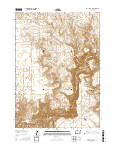
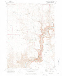
2017 Map of Rinehart Canyon
USGS Topo · Published 2017About this map
Owyhee Canyon dominates this high-desert landscape in Malheur County, where the Owyhee River carves a deep, winding path through the terrain. The map reveals a land defined by water management and ranching infrastructure, evidenced by a network of catchments such as Gallagher Reservoir, Jackson Cr Reservoir, and the Lower Fort Cr Reservoir. These features, along with Hoot Owl Spring and Rinehart Spring, illustrate the vital importance of water sources in this arid environment. Transportation is limited to a few arterial routes like Rinehart Ranch Rd and Miller Ln, which provide access to landforms like Sand Basin and Iron Point. The density of named reservoirs and springs suggests a long-standing reliance on these specific points for livestock and regional land use in the early twenty-first century.
Find a feature on this map
30 named features on this map. Tap any name to fly to it.
Don’t see what you’re looking for? This feature index may not catch every label — zoom into the map to look around manually.
Map Details
Editions of this 2017 Rinehart Canyon Map
This is the sole edition of this map. No revisions or reprints were ever made.
Other maps of this area

1955 · Boise
USGS Topo · 1:250,000

1958 · Boise
USGS Topo · 1:250,000

1962 · Boise
USGS Topo · 1:250,000

1972 · Cedar Mountain
USGS Topo · 1:24,000
1972 · Wrangle Butte
USGS Topo · 1:24,000
1972 · Lambert Rocks
USGS Topo · 1:24,000

1972 · Burnt Flat
USGS Topo · 1:24,000

1972 · Big Mud Flat
USGS Topo · 1:24,000
1972 · Sacramento Butte
USGS Topo · 1:24,000
1972 · Rinehart Canyon
USGS Topo · 1:24,000