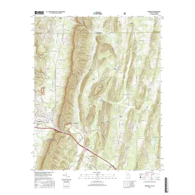
2017 Map of Ringgold
USGS Topo · Published 2017About this map
Ringgold serves as a focal point for this landscape where Georgia meets Tennessee, positioned along the banks of South Chickamauga Creek. The terrain is defined by the prominent ridgelines of White Oak Mountain and Taylor Ridge, which channel the surrounding valleys and watercourses like Tiger Creek and Cherokee Branch. To the south and west, the Chattahoochee National Forest covers a significant portion of the foothills, while the northern sections reveal a network of rural settlements such as Apison, Salem, and Cherokee Valley. Family history is deeply rooted across the quadrangle, evident in the numerous burial grounds including Old Ringgold Cemetery, Mount Vernon Cemetery, and Stone Cemetery. The presence of Catoosa Springs and the VTS Catoosa training site indicates the area's long-standing strategic and natural significance.
Find a feature on this map
169 named features on this map. Tap any name to fly to it.
Don’t see what you’re looking for? This feature index may not catch every label — zoom into the map to look around manually.
Map Details
Editions of this 2017 Ringgold Map
This is the sole edition of this map. No revisions or reprints were ever made.
Other maps of this area

1886 · Dalton
USGS Topo · 1:125,000

1886 · Cleveland
USGS Topo · 1:125,000

1886 · Ringgold
USGS Topo · 1:125,000

1888 · Chattanooga
USGS Topo · 1:125,000

1892 · Ringgold
USGS Topo · 1:125,000

1892 · Cleveland
USGS Topo · 1:125,000

1892 · Dalton
USGS Topo · 1:125,000

1893 · Chattanooga
USGS Topo · 1:125,000

1895 · Cleveland
USGS Topo · 1:125,000

1897 · Dalton
USGS Topo · 1:125,000