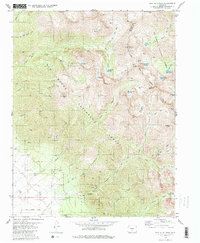
1980 Map of Rio Alto Peak
USGS Topo · Published 1985About this map
Rito Alto Peak and the high ridges of the Sangre de Cristo Mountains define this 1980 survey, where the boundary between Saguache and Custer counties follows the jagged continental divide. The landscape is a complex network of glacial basins and high-altitude water bodies, including Rito Alto Lake, South Crestone Lake, and Iris Lake. Human activity is concentrated along the lower elevations and through arduous mountain crossings like Hermit Pass and Venable Pass. A notable piece of historical infrastructure, the Old Railroad Grade, runs along the western base of the range near the Crestone Cem. The presence of several Prospect markings and a Gravel Pit indicates the legacy of resource exploration in the canyons of the Rio Grande National Forest and San Isabel National Forest.
Find a feature on this map
56 named features on this map. Tap any name to fly to it.
Don’t see what you’re looking for? This feature index may not catch every label — zoom into the map to look around manually.
Map Details
Editions of this 1980 Rio Alto Peak Map
4 editions found
Other maps of this area

1950 · Valley View Hot Springs
USGS Topo · 1:24,000

1954 · Trinidad
USGS Topo · 1:250,000

1954 · Pueblo
USGS Topo · 1:250,000

1955 · Trinidad
USGS Topo · 1:250,000

1957 · Pueblo
USGS Topo · 1:250,000

1958 · Trinidad
USGS Topo · 1:250,000

1958 · Pueblo
USGS Topo · 1:250,000

1958 · Beckwith Mountain
USGS Topo · 1:24,000

1959 · Trinidad
USGS Topo · 1:250,000

1959 · Electric Peak
USGS Topo · 1:62,500