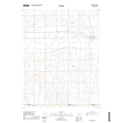
2017 Map of Riverton
USGS Topo · Published 2017About this map
Riverton occupies a strategic bend of the Republican River in southern Nebraska, just north of the Nebraska-Kansas border. This modern survey illustrates a highly managed riparian landscape where agricultural water rights are central to the geography. The town's grid, featuring streets like Main St and Lincoln St, is bordered by the Franklin Canal and the Franklin S Side Pump Canal, which together divert river water to sustain the surrounding valley. Family history is anchored by the presence of Stevens Cem and Fuller Cem, situated on the bluffs overlooking the river plain. Beyond the irrigated bottoms, the terrain transitions into a complex network of drainages such as Lohff Cr and School Cr, punctuated by small upland impoundments like Kugler Reservoir and Hawkins Reservoir that characterize the water storage needs of this borderland region.
Find a feature on this map
45 named features on this map. Tap any name to fly to it.
Don’t see what you’re looking for? This feature index may not catch every label — zoom into the map to look around manually.
Map Details
Editions of this 2017 Riverton Map
This is the sole edition of this map. No revisions or reprints were ever made.
Other maps of this area

1893 · Smith Center
USGS Topo · 1:125,000

1897 · Red Cloud
USGS Topo · 1:125,000

1940 · Red Cloud
USGS Topo · 1:62,500

1942 · Red Cloud
USGS Topo · 1:62,500

1955 · Grand Island
USGS Topo · 1:250,000

1955 · Beloit
USGS Topo · 1:250,000

1957 · Grand Island
USGS Topo · 1:250,000

1958 · Grand Island
USGS Topo · 1:250,000

1959 · Beloit
USGS Topo · 1:250,000
1973 · Cora
USGS Topo · 1:24,000