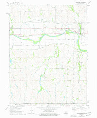
1974 Map of Riverton
USGS Topo · Published 1977About this map
Republican River valley bottomlands dominate the landscape of south-central Nebraska in this mid-1970s survey, where an intricate irrigation network supports the local agricultural economy. The Franklin Canal, Franklin Pump Canal, and South Side Canal trace the contours of the valley, reflecting the 20th-century engineering required to manage water in this prairie region. The village of Riverton sits at the junction of the Burlington Northern railroad and several major drainage systems, including Thompson Creek.
Find a feature on this map
20 named features on this map. Tap any name to fly to it.
Don’t see what you’re looking for? This feature index may not catch every label — zoom into the map to look around manually.
Map Details
Editions of this 1974 Riverton Map
This is the sole edition of this map. No revisions or reprints were ever made.
Other maps of this area

1893 · Smith Center
USGS Topo · 1:125,000

1897 · Red Cloud
USGS Topo · 1:125,000

1940 · Red Cloud
USGS Topo · 1:62,500

1942 · Red Cloud
USGS Topo · 1:62,500

1955 · Grand Island
USGS Topo · 1:250,000

1955 · Beloit
USGS Topo · 1:250,000

1957 · Grand Island
USGS Topo · 1:250,000

1958 · Grand Island
USGS Topo · 1:250,000

1959 · Beloit
USGS Topo · 1:250,000
1973 · Cora
USGS Topo · 1:24,000