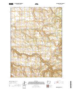
2020 Map of Roaring Springs SE
USGS Topo · Published 2020About this map
Donner und Blitzen River flows through the eastern edge of this Harney County landscape, carving through a high-elevation plateau defined by significant drainage systems and steep escarpments. The topography is dominated by the dramatic ascent of the Catlow Rim in the southwest, where the land drops sharply toward the Catlow Valley. Local water sources are critical to this arid environment, evidenced by seasonal flows like Dry Cr and more permanent points such as Three Springs. Transportation across this remote ranching and grazing country relies on a sparse network of unpaved routes, including Lauserica Rd and Lower Crossing Rd, which navigate the complex terrain around Threemile Canyon and the headwaters of Home Cr.
Find a feature on this map
13 named features on this map. Tap any name to fly to it.
Don’t see what you’re looking for? This feature index may not catch every label — zoom into the map to look around manually.
Map Details
Editions of this 2020 Roaring Springs SE Map
This is the sole edition of this map. No revisions or reprints were ever made.
Other maps of this area

1955 · Adel
USGS Topo · 1:250,000

1957 · Adel
USGS Topo · 1:250,000

1958 · Adel
USGS Topo · 1:250,000

1962 · Adel
USGS Topo · 1:250,000

1967 · Roaring Springs
USGS Topo · 1:24,000

1968 · Tombstone Canyon
USGS Topo · 1:24,000

1968 · Fish Lake
USGS Topo · 1:24,000

1968 · Roaring Springs SE
USGS Topo · 1:24,000

1968 · Ankle Creek
USGS Topo · 1:24,000

1971 · Garrison Lake
USGS Topo · 1:24,000