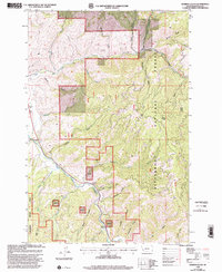
1998 Map of Robbins Gulch
USGS Topo · Published 2002About this map
The East Fork Bitterroot River defines the drainage patterns of this Ravalli County landscape, as mapped in the late 1990s. The small settlement of Conner and the nearby Corner Ch serve as local landmarks along the river valley, while the presence of a Historical Marker and a Gaging Station further south suggests the significance of this corridor for travel and resource monitoring. The terrain is deeply incised by numerous gulches, including Robbins Gulch, Medicine Tree Creek, and Billy Goat Gulch, reflecting the complex geography of the Bitterroot National Forest.
Find a feature on this map
41 named features on this map. Tap any name to fly to it.
Don’t see what you’re looking for? This feature index may not catch every label — zoom into the map to look around manually.
Map Details
Editions of this 1998 Robbins Gulch Map
This is the sole edition of this map. No revisions or reprints were ever made.
Other maps of this area

1901 · Hamilton
USGS Topo · 1:125,000

1909 · Sapphire
USGS Topo · 1:125,000

1947 · Butte
USGS Topo · 1:250,000

1955 · Dillon
USGS Topo · 1:250,000

1956 · Elk City
USGS Topo · 1:250,000

1956 · Hamilton
USGS Topo · 1:250,000

1957 · Dillon
USGS Topo · 1:250,000

1958 · Butte
USGS Topo · 1:250,000

1958 · Dillon
USGS Topo · 1:250,000

1959 · Hamilton
USGS Topo · 1:250,000