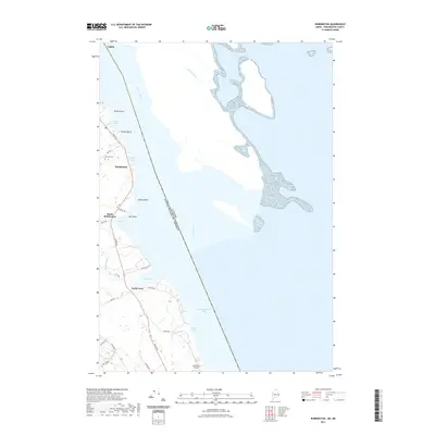
2021 Map of Robbinston
USGS Topo · Published 2021About this map
The St. Croix River defines the eastern edge of Washington County in this coastal survey, marking the international boundary between the United States and Canada. This maritime landscape is shaped by a series of prominent points and coves, including Brooks Cove and Pollock Cove, which historically supported the region's fishing and timber activities. The settlement of Robbinston serves as a central hub, with South Robbinston and North Perry following the path of River Rd as it traces the shoreline.
Find a feature on this map
34 named features on this map. Tap any name to fly to it.
Don’t see what you’re looking for? This feature index may not catch every label — zoom into the map to look around manually.
Map Details
Editions of this 2021 Robbinston Map
This is the sole edition of this map. No revisions or reprints were ever made.
Other maps of this area

1907 · Eastport
USGS Topo · 1:48,000

1908 · Eastport
USGS Topo · 1:62,500

1929 · Robbinston
USGS Topo · 1:48,000

1931 · Robbinston
USGS Topo · 1:62,500

1943 · Eastport
USGS Topo · 1:62,500

1945 · Eastport
USGS Topo · 1:62,500

1949 · Robbinston
USGS Topo · 1:24,000

1949 · Pembroke
USGS Topo · 1:24,000

1949 · Red Beach
USGS Topo · 1:24,000

1949 · Devils Head
USGS Topo · 1:24,000