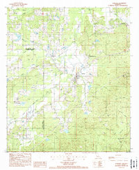
1988 Map of Robeline
USGS Topo · Published 1988About this map
Robeline serves as the focal point for this late-1980s topographic study, situated where the wooded lowlands of Natchitoches Parish meet the drainage basins of central Louisiana. The landscape is defined by an intricate network of waterways, including Little Bayou and Dupont Bayou, which meander through a terrain marked by small settlements like Shamrock and Watson. A notable cultural landmark is the Los Adaes State Commemorative Area, preserving the site of the 18th-century Spanish capital of Tejas. The map illustrates a rural economy tied to the land, evidenced by features such as a Clay Pit and numerous creek systems like Trudo Creek and Coal Kiln Creek. Pipelines and transmission lines cut across the timbered sections, reflecting the modern infrastructure overlaying the traditional parish line divisions between Sabine and Natchitoches.
Find a feature on this map
29 named features on this map. Tap any name to fly to it.
Don’t see what you’re looking for? This feature index may not catch every label — zoom into the map to look around manually.
Map Details
Editions of this 1988 Robeline Map
This is the sole edition of this map. No revisions or reprints were ever made.
Other maps of this area

1935 · Hagewood
USGS Topo · 1:31,680

1937 · Bellwood
USGS Topo · 1:31,680

1937 · Campti SW
USGS Topo · 1:31,680

1938 · Hollis Creek
USGS Topo · 1:31,680

1938 · Allen
USGS Topo · 1:31,680

1942 · Many
USGS Topo · 1:62,500

1943 · Many
USGS Topo · 1:62,500

1943 · Provencal
USGS Topo · 1:62,500

1944 · Campti
USGS Topo · 1:62,500

1945 · Provencal
USGS Topo · 1:62,500