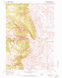
1967 Map of Robinson Canyon
USGS Topo · Published 1971About this map
Crazy Woman Creek winds through the eastern portion of this Wyoming landscape, defining a valley floor punctuated by irrigation infrastructure like the Northside Ditch. In the late 1960s, this area of Johnson County was characterized by its intricate drainage systems and high-country landmarks, including the deeply carved Robinson Canyon and its Middle Fork. The mapping of fine red dashed lines to indicate selected fence lines suggests a territory organized around ranching and livestock management, where water sources like Tetley Spring and Cole Spring were vital assets.
Find a feature on this map
23 named features on this map. Tap any name to fly to it.
Don’t see what you’re looking for? This feature index may not catch every label — zoom into the map to look around manually.
Map Details
Editions of this 1967 Robinson Canyon Map
This is the sole edition of this map. No revisions or reprints were ever made.
Other maps of this area

1900 · Fort McKinney
USGS Topo · 1:125,000

1903 · Fort McKinney
USGS Topo · 1:125,000

1955 · Sheridan
USGS Topo · 1:250,000

1955 · Arminto
USGS Topo · 1:250,000

1958 · Sheridan
USGS Topo · 1:250,000

1958 · Arminto
USGS Topo · 1:250,000

1961 · Schlict Draw
USGS Topo · 1:24,000

1962 · Sheridan
USGS Topo · 1:250,000

1962 · Arminto
USGS Topo · 1:250,000

1963 · Mayoworth
USGS Topo · 1:62,500