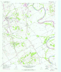
1957 Map of Robinson
USGS Topo · Published 1977About this map
The Brazos River meanders along the eastern edge of this landscape, its path defined by a series of levees and drainage ditches that supported the agricultural operations of the mid-20th century. This area south of Waco is characterized by the convergence of several waterways, including Castleman Creek, Dry Creek, and Bull Hide Creek, which flow through the fertile plains towards the river. The map details the growth of Robinson and the smaller clusters of Downsville and Rosenthal, providing a look at the community infrastructure of the time. The landscape is punctuated by numerous local landmarks such as Rosenthal High Sch and St Pauls Ch. A notable historical trace is the Old Railroad Grade running north-south, signaling the area's older transportation network before it was superseded by the evolving road system. Genealogists will find significant value in the documentation of several family and community sites, including Mt Pleasant Cem and Christian Chapel.
Find a feature on this map
33 named features on this map. Tap any name to fly to it.
Don’t see what you’re looking for? This feature index may not catch every label — zoom into the map to look around manually.
Map Details
Editions of this 1957 Robinson Map
4 editions found
Other maps of this area

1892 · Temple
USGS Topo · 1:125,000

1892 · Waco
USGS Topo · 1:125,000

1920 · Waco
USGS Topo · 1:125,000

1920 · Mart
USGS Topo · 1:62,500

1924 · Waco 4-c
USGS Topo · 1:48,000

1931 · Elm Mott
USGS Topo · 1:62,500

1954 · Waco
USGS Topo · 1:250,000

1955 · Waco
USGS Topo · 1:250,000

1957 · Bruceville
USGS Topo · 1:24,000

1957 · Lorena
USGS Topo · 1:24,000