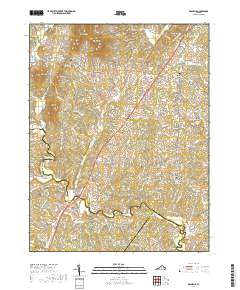
2019 Map of Rochelle
USGS Topo · Published 2019About this map
Madison and the rolling terrain of southern Madison County are anchored by a series of long-established agricultural communities and family ridges in this 2019 study. The landscape is defined by the Rapidan River and its numerous tributaries, including Whiteoak Run and Elk Run, which carve through the prominent uplands of Tippets Mtn and German Ridge. This area retains much of its rural character, with crossroads like Shelby and Wolftown serving as focal points for local history. Genealogists will find significant value in the detailed documentation of community landmarks, including the Rose Park United Methodist Cem and Mount Nebo Lutheran Church Cem. The map traces the historical transport patterns along S Seminole Trl, showing how settlements like Pratts and Rochelle developed along these established transit corridors between the river bottoms and the mountain foothills.
Find a feature on this map
102 named features on this map. Tap any name to fly to it.
Don’t see what you’re looking for? This feature index may not catch every label — zoom into the map to look around manually.
Map Details
Editions of this 2019 Rochelle Map
This is the sole edition of this map. No revisions or reprints were ever made.
Other maps of this area

1892 · Gordonsville
USGS Topo · 1:125,000

1930 · Madison
USGS Topo · 1:48,000

1933 · Madison
USGS Topo · 1:62,500

1935 · Charlottesville
USGS Topo · 1:62,500

1939 · Charlottesville
USGS Topo · 1:62,500

1949 · Charlottesville
USGS Topo · 1:250,000

1949 · Charlottesville
USGS Topo · 1:62,500

1956 · Charlottesville
USGS Topo · 1:250,000

1961 · Gordonsville
USGS Topo · 1:62,500

1961 · Rapidan
USGS Topo · 1:62,500