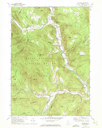
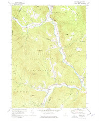
1970 Map of Rochester
USGS Topo · Published 1972About this map
The White River valley carves through this mountainous section of the Green Mountain National Forest, serving as the primary corridor for settlement and industry in the early 1970s. The village of Rochester sits at the northern end of this corridor, with smaller hamlets like Taleville, Emerson, and Stockbridge following the river's bend southward. This map reveals a landscape where valley agriculture and gravel extraction, noted at several Gravel Pits, exist alongside steep forested peaks such as Little Wilcox Peak and Wilcox Peak.
Find a feature on this map
56 named features on this map. Tap any name to fly to it.
Don’t see what you’re looking for? This feature index may not catch every label — zoom into the map to look around manually.
Map Details
Editions of this 1970 Rochester Map

Other maps of this area

1891 · Rutland
USGS Topo · 1:62,500

1893 · Rutland
USGS Topo · 1:62,500

1911 · Woodstock
USGS Topo · 1:62,500

1913 · Woodstock
USGS Topo · 1:62,500

1915 · Rochester
USGS Topo · 1:62,500

1917 · Rochester
USGS Topo · 1:62,500

1919 · Royalton
USGS Topo · 1:62,500

1924 · Randolph
USGS Topo · 1:48,000

1926 · Randolph
USGS Topo · 1:62,500

1943 · Woodstock
USGS Topo · 1:62,500