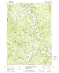
1970 Map of Rochester
USGS Topo · Published 1988About this map
The White River corridor serves as the primary artery through this Vermont landscape, connecting the valley settlements of Rochester and Stockbridge. This 1970s survey, updated in the late 1980s, reveals a terrain defined by steep elevations and narrow valley bottoms where human activity is concentrated. Within the Green Mountain National Forest, the map identifies peaks such as Rogers Peak and Little Wilcox Peak, while the valleys show the persistent footprint of small hamlets like Talleville and New Boston. Local history and genealogy are anchored by landmarks like St Dennis Ch, Woodlawn Cem, and Maplewood Cem. The presence of several Gravel Pits and older Mines near the northern boundary suggests a reliance on the physical geology of the area. Narrow roads such as Liberty Hill Road and Michigan Road snake through the hills, illustrating the enduring transport patterns of the Windsor and Rutland County borders.
Find a feature on this map
56 named features on this map. Tap any name to fly to it.
Don’t see what you’re looking for? This feature index may not catch every label — zoom into the map to look around manually.
Map Details
Editions of this 1970 Rochester Map
Other maps of this area

1891 · Rutland
USGS Topo · 1:62,500

1893 · Rutland
USGS Topo · 1:62,500

1911 · Woodstock
USGS Topo · 1:62,500

1913 · Woodstock
USGS Topo · 1:62,500

1915 · Rochester
USGS Topo · 1:62,500

1917 · Rochester
USGS Topo · 1:62,500

1919 · Royalton
USGS Topo · 1:62,500

1924 · Randolph
USGS Topo · 1:48,000

1926 · Randolph
USGS Topo · 1:62,500

1943 · Woodstock
USGS Topo · 1:62,500