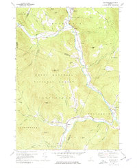
1970 Map of Rochester
USGS Topo · Published 1977About this map
Rochester serves as the northern hub of this map, situated where the West Branch White River meets the main stem. The terrain is characterized by the high peaks of the Green Mountain National Forest, including Rogers Peak and Little Wilcox Peak, which hem in the narrow river valleys. These corridors served as the primary routes for settlement and transport, evidenced by the cluster of small communities such as Talleville, Emerson, and Jerusalem following the water's edge.
Find a feature on this map
53 named features on this map. Tap any name to fly to it.
Don’t see what you’re looking for? This feature index may not catch every label — zoom into the map to look around manually.
Map Details
Editions of this 1970 Rochester Map
Other maps of this area

1891 · Rutland
USGS Topo · 1:62,500

1893 · Rutland
USGS Topo · 1:62,500

1911 · Woodstock
USGS Topo · 1:62,500

1913 · Woodstock
USGS Topo · 1:62,500

1915 · Rochester
USGS Topo · 1:62,500

1917 · Rochester
USGS Topo · 1:62,500

1919 · Royalton
USGS Topo · 1:62,500

1924 · Randolph
USGS Topo · 1:48,000

1926 · Randolph
USGS Topo · 1:62,500

1943 · Woodstock
USGS Topo · 1:62,500