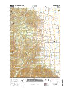
2014 Map of Rock Creek
USGS Topo · Published 2014About this map
Whitman National Forest dominates the western portion of this Baker County landscape, where the high elevations of the Elkhorn Mountains transition into the North Powder Valley. The settlement of Rock Creek is a focal point for a complex irrigation network of historical ditches and sloughs, including the Penstock-Olsen Ditch, Blume Zilkey Ditch, and Gardner Mill Race Ditch. This intricate water management system reflects a long history of cattle ranching and agriculture supported by the seasonal runoff from peaks like Antelope Peak.
Find a feature on this map
108 named features on this map. Tap any name to fly to it.
Don’t see what you’re looking for? This feature index may not catch every label — zoom into the map to look around manually.
Map Details
Editions of this 2014 Rock Creek Map
This is the sole edition of this map. No revisions or reprints were ever made.
Other maps of this area

1901 · Baker City
USGS Topo · 1:125,000

1901 · Sumpter
USGS Topo · 1:125,000

1906 · Telocaset
USGS Topo · 1:125,000

1953 · Pendleton
USGS Topo · 1:250,000

1955 · Baker
USGS Topo · 1:250,000

1955 · Grangeville
USGS Topo · 1:250,000

1955 · Canyon City
USGS Topo · 1:250,000

1956 · Pendleton
USGS Topo · 1:250,000

1959 · Baker
USGS Topo · 1:250,000

1959 · Grangeville
USGS Topo · 1:250,000