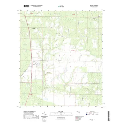
2021 Map of Rock Hill
USGS Topo · Published 2021About this map
Rock Hill and the surrounding pine-studded landscape of Walton County are defined by a complex network of creeks and drainage basins that feed into the Choctawhatchee Bay watershed. This 2021 survey illustrates a region where long-standing rural settlements like Freeport meet the expansive western boundaries of Eglin Air Force Base. The terrain is marked by distinctive topographic features such as Steep Head and Owls Head, while the Florida National Scenic Trail meanders through the wetlands and forests of the southern half of the quadrangle. Extensive creek systems, including Seven Runs, Lafayette Creek, and Alice Creek, emphasize the importance of water management and natural drainage in this low-lying Florida corridor. The map preserves local geographic memory through names like Old Walton Bridge and the various branches such as Big Branch and White Creek.
Find a feature on this map
55 named features on this map. Tap any name to fly to it.
Don’t see what you’re looking for? This feature index may not catch every label — zoom into the map to look around manually.
Map Details
Editions of this 2021 Rock Hill Map
This is the sole edition of this map. No revisions or reprints were ever made.
Other maps of this area

1935 · De Funiak Springs
USGS Topo · 1:48,000

1936 · Point Washington
USGS Topo · 1:48,000

1938 · De Funiak Springs
USGS Topo · 1:62,500

1939 · Point Washington
USGS Topo · 1:62,500

1944 · Bruce
USGS Topo · 1:24,000

1945 · Bruce
USGS Topo · 1:31,680

1948 · Ponce De Leon
USGS Topo · 1:24,000

1949 · Redbay
USGS Topo · 1:24,000

1950 · Ponce De Leon
USGS Topo · 1:24,000

1950 · Redbay
USGS Topo · 1:24,000