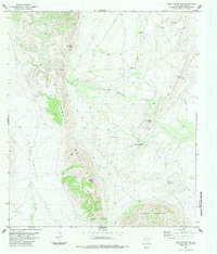
1983 Map of Rock House Gap
USGS Topo · Published 1984About this map
The Del Norte Mountains and Cochran Mountains dominate this high-desert landscape in Brewster County, where the scarcity of water is evidenced by the density of named springs and windmills. Natural features like Sulphur Springs and Shaler Spring are joined by man-made infrastructure including the Twin China Windmill, Axtell Windmill, and Thompson Windmill. These markers define a pastoral and industrial network where life and labor followed the reliable sources of water between the peaks and canyons. The terrain transitions from the steep grades of Black Peak and Doubtful Canyon into the lower expanse of Chalk Valley, while a series of Jeep Trails provides the primary means of navigating the arid basins of Dugout Creek and Maravillas Creek.
Find a feature on this map
22 named features on this map. Tap any name to fly to it.
Don’t see what you’re looking for? This feature index may not catch every label — zoom into the map to look around manually.
Map Details
Editions of this 1983 Rock House Gap Map
This is the sole edition of this map. No revisions or reprints were ever made.
Other maps of this area

1895 · Alpine
USGS Topo · 1:125,000

1917 · Santiago Peak
USGS Topo · 1:62,500

1917 · Buck Hill
USGS Topo · 1:62,500

1918 · Bone Spring
USGS Topo · 1:125,000

1918 · Buck Hill
USGS Topo · 1:62,500

1918 · Santiago Peak
USGS Topo · 1:62,500

1920 · Monument Spring
USGS Topo · 1:62,500

1921 · Monument Spring
USGS Topo · 1:62,500

1925 · Buck Hill
USGS Topo · 1:62,500
1938 · Santiago Peak
USGS Topo · 1:62,500