
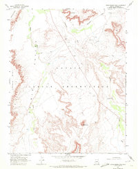
1968 Map of Rock Point SW
USGS Topo · Published 1971About this map
Carson Mesa dominates this high-desert landscape in the northeast corner of the Navajo Indian Reservation. This 1968 survey documents a remote portion of Apache County characterized by vast plateaus and the drainage systems that define the region's topography. The western portion of the map is shaped by the Dibe Cha a Valley, where the ephemeral Dibe Cha a Wash winds through the terrain. A historical Old Treaty Boundary cuts through the eastern edge of the quadrangle, serving as a significant legal and cartographic marker of land administration in the mid-20th century. Cultural markers are sparse in this area, but the presence of a Trading Post and a Water Tank indicates the essential points of contact and resource management for those living on and traversing the reservation during this period.
Find a feature on this map
10 named features on this map. Tap any name to fly to it.
Don’t see what you’re looking for? This feature index may not catch every label — zoom into the map to look around manually.
Map Details
Editions of this 1968 Rock Point SW Map
This is the sole edition of this map. No revisions or reprints were ever made.
Other maps of this area

1892 · Canyon De Chelly
USGS Topo · 1:250,000

1954 · Shiprock
USGS Topo · 1:250,000

1958 · Shiprock
USGS Topo · 1:250,000

1959 · Shiprock
USGS Topo · 1:250,000
1968 · Dancing Rocks
USGS Topo · 1:24,000
1968 · White Point
USGS Topo · 1:24,000
1968 · Many Farms NE
USGS Topo · 1:24,000
1968 · Tall Mesa
USGS Topo · 1:24,000

1968 · Windy Valley
USGS Topo · 1:24,000
1968 · Little Round Rock
USGS Topo · 1:24,000