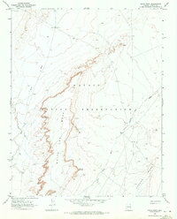
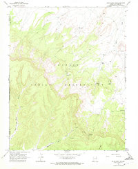
1968 Map of White Point
USGS Topo · Published 1972About this map
The high plateau of the Navajo Indian Reservation dominates this 1968 landscape in Apache County, defined by dramatic escarpments and desert drainage systems. The survey centers on the prominent White Point Mesa and the specific landmark of White Point, where the terrain drops sharply toward the surrounding plains. The drainage patterns of the era are clearly etched through the sandy soil, most notably along Burro Wash in the west and Trading Post Wash in the central corridor. This documentation by the U.S. Geological Survey captures a sparsely populated region during the late 1960s, where human infrastructure was limited to isolated features like a Water Tank and unimproved roads, highlighting the vastness of Carson Mesa to the southeast.
Find a feature on this map
10 named features on this map. Tap any name to fly to it.
Don’t see what you’re looking for? This feature index may not catch every label — zoom into the map to look around manually.
Map Details
Editions of this 1968 White Point Map
This is the sole edition of this map. No revisions or reprints were ever made.
Other maps of this area

1892 · Canyon De Chelly
USGS Topo · 1:250,000

1954 · Shiprock
USGS Topo · 1:250,000

1958 · Shiprock
USGS Topo · 1:250,000

1959 · Shiprock
USGS Topo · 1:250,000

1968 · Rock Point SW
USGS Topo · 1:24,000
1968 · Tall Mesa
USGS Topo · 1:24,000

1968 · Windy Valley
USGS Topo · 1:24,000
1968 · Sweetwater Mesa
USGS Topo · 1:24,000
1968 · Rough Rock
USGS Topo · 1:24,000
1968 · Rough Rock NW
USGS Topo · 1:24,000