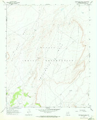
1968 Map of Sweetwater Mesa
USGS Topo · Published 1972About this map
Sweetwater Mesa dominates this high-desert landscape in the northeastern corner of Arizona during the late 1960s. Located within the Navajo Indian Reservation along the boundary of Navajo and Apache Counties, the area shows a sparse network of unimproved dirt roads and light-duty tracks connecting isolated points of activity. Small settlements such as Al Tse Toh and Toh Ah Glau appear alongside essential water resources like the Cistern and several Water Tanks, which supported inhabitants and livestock in this arid environment.
Find a feature on this map
15 named features on this map. Tap any name to fly to it.
Don’t see what you’re looking for? This feature index may not catch every label — zoom into the map to look around manually.
Map Details
Editions of this 1968 Sweetwater Mesa Map
2 editions found
Other maps of this area

1883 · Marsh Pass
USGS Topo · 1:250,000

1892 · Marsh Pass
USGS Topo · 1:250,000

1892 · Canyon De Chelly
USGS Topo · 1:250,000

1954 · Shiprock
USGS Topo · 1:250,000

1956 · Marble Canyon
USGS Topo · 1:250,000

1958 · Shiprock
USGS Topo · 1:250,000

1959 · Shiprock
USGS Topo · 1:250,000

1959 · Marble Canyon
USGS Topo · 1:250,000

1961 · Marble Canyon
USGS Topo · 1:250,000
1968 · Chilchinbito
USGS Topo · 1:24,000