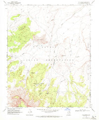
1968 Map of Chilchinbito
USGS Topo · Published 1972About this map
Chilchinbito serves as the focal point of this late 1960s survey, situated within the Navajo Indian Reservation near the boundary of Navajo and Apache counties. The settlement is centered around the Chilchinbito Trading Post, a critical hub for the local community during this era. The surrounding landscape is defined by its distinct geology, featuring prominent landmarks such as Small White Mesa and White Rock Mesa, along with an area of active Sand Dunes. Water sources are vital in this environment, indicated by the presence of Chilchinbito Spring, Sweetwater Spring, and the White Rock Mesa Windmill. The network of trails and jeep trails crisscrossing the terrain illustrates the traditional and modern transport patterns of the Navajo Nation before significant road development altered the region.
Find a feature on this map
26 named features on this map. Tap any name to fly to it.
Don’t see what you’re looking for? This feature index may not catch every label — zoom into the map to look around manually.
Map Details
Editions of this 1968 Chilchinbito Map
This is the sole edition of this map. No revisions or reprints were ever made.
Other maps of this area

1883 · Marsh Pass
USGS Topo · 1:250,000

1892 · Marsh Pass
USGS Topo · 1:250,000

1892 · Canyon De Chelly
USGS Topo · 1:250,000

1954 · Shiprock
USGS Topo · 1:250,000

1956 · Marble Canyon
USGS Topo · 1:250,000

1958 · Shiprock
USGS Topo · 1:250,000

1959 · Shiprock
USGS Topo · 1:250,000

1959 · Marble Canyon
USGS Topo · 1:250,000

1961 · Marble Canyon
USGS Topo · 1:250,000
1968 · Kayenta East
USGS Topo · 1:24,000