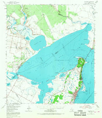
1954 Map of Rockport
USGS Topo · Published 1968About this map
Live Oak Peninsula defines the coastal character of this mid-century Texas survey, anchoring the growing community of Rockport and the adjacent settlement of Fulton. The landscape is a complex network of shallow bays and tidal flats, where the Mission River and Aransas River empty into the expansive waters of Copano Bay and Mission Bay. The infrastructure of the 1950s is clearly visible, showing the emergence of the Aransas County Airport and the development of the Fulton Beach Oil Field and West Fulton Beach Oil Field, which speak to the region's petroleum-driven economy. Along the western shore, the small town of Bayside sits overlooking the mouth of the river systems, while the Intracoastal Waterway cuts through the eastern bays, marking the vital shipping artery of the Gulf Coast. Local history details include the Rockport Cem and the small residential cluster at Copano Village.
Find a feature on this map
53 named features on this map. Tap any name to fly to it.
Don’t see what you’re looking for? This feature index may not catch every label — zoom into the map to look around manually.
Map Details
Editions of this 1954 Rockport Map
2 editions found
Other maps of this area

1925 · Aransas Pass
USGS Topo · 1:62,500

1925 · Corpus Christi
USGS Topo · 1:62,500

1950 · Corpus Christi
USGS Topo · 1:250,000

1951 · Corpus Christi
USGS Topo · 1:62,500

1951 · Allyns Bight
USGS Topo · 1:24,000

1952 · St. Charles Bay SW
USGS Topo · 1:24,000

1952 · St. Charles Bay
USGS Topo · 1:24,000

1952 · Tivoli SW
USGS Topo · 1:24,000

1953 · Beeville
USGS Topo · 1:250,000

1954 · Rockport
USGS Topo · 1:62,500