
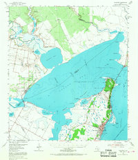
1954 Map of Rockport
USGS Topo · Published 1956About this map
Live Oak Peninsula anchors this mid-century study of the Aransas County coast, where the urban center of Rockport and the nearby community of Fulton front the shallow waters of Aransas Bay. The landscape is defined by the intersection of water and industry, notably the Fulton Beach Oil Field and Copano Bay Oil Field, which illustrate the post-war energy boom along the Texas Gulf Coast. Navigation and aviation are central to this 1950s environment, evidenced by the Aransas County Airport and the Intracoastal Waterway skirting the eastern reefs.
Find a feature on this map
53 named features on this map. Tap any name to fly to it.
Don’t see what you’re looking for? This feature index may not catch every label — zoom into the map to look around manually.
Map Details
Editions of this 1954 Rockport Map
2 editions found
Other maps of this area

1925 · Aransas Pass
USGS Topo · 1:62,500

1925 · Corpus Christi
USGS Topo · 1:62,500

1950 · Corpus Christi
USGS Topo · 1:250,000

1951 · Corpus Christi
USGS Topo · 1:62,500

1951 · Allyns Bight
USGS Topo · 1:24,000

1952 · St. Charles Bay SW
USGS Topo · 1:24,000

1952 · St. Charles Bay
USGS Topo · 1:24,000

1952 · Tivoli SW
USGS Topo · 1:24,000

1953 · Beeville
USGS Topo · 1:250,000

1954 · Aransas Pass
USGS Topo · 1:24,000