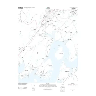
2013 Map of Rockwood
USGS Topo · Published 2013About this map
Rockwood sits at the foot of Walden Ridge, serving as a gateway between the high plateau and the expansive waters of Watts Bar Lake. This landscape is defined by the Tennessee River's reach, where islands and bars like Thief Neck Island and Kings Bar break the surface near White Bluff. The area shows a transition from the industrial heritage of Eagle Furnace to modern residential developments along the shoreline, including Woodland Cove and Irwinton Shores.
Find a feature on this map
198 named features on this map. Tap any name to fly to it.
Don’t see what you’re looking for? This feature index may not catch every label — zoom into the map to look around manually.
Map Details
Editions of this 2013 Rockwood Map
This is the sole edition of this map. No revisions or reprints were ever made.
Other maps of this area

1887 · Kingston
USGS Topo · 1:125,000

1891 · Kingston
USGS Topo · 1:125,000

1893 · Kingston
USGS Topo · 1:125,000

1935 · Rockwood
USGS Topo · 1:24,000

1935 · Harriman
USGS Topo · 1:24,000

1936 · Roddy
USGS Topo · 1:24,000
1936 · Ozone
USGS Topo · 1:24,000

1936 · Cardiff
USGS Topo · 1:24,000

1936 · Spring City
USGS Topo · 1:24,000
1936 · Pattie Gap
USGS Topo · 1:24,000