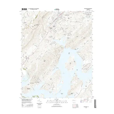
2016 Map of Rockwood
USGS Topo · Published 2016About this map
Rockwood sits at the foot of the Cumberland Walden Escarpment Ridge, where the steep rise of Mt Roosevelt meets the flooded lowlands of the Tennessee River valley. The landscape is defined by the expansive waters of Watts Bar Lake, which surrounds prominent features like Thief Neck Island and creates a complex shoreline of points and bays including Cane Hollow and Johnson Bend. This modern survey illustrates the transition from the high ridges of Willet Mtn down to the residential developments of Lakemont Heights and Highland Forest. Genealogy and local history are well-represented by a high density of burial grounds, including the Winton Chapel Cem and Rockwood Cem, as well as older site names like Eagle Furnace and Pioneer Village that hint at the region's industrial and early settlement heritage.
Find a feature on this map
200 named features on this map. Tap any name to fly to it.
Don’t see what you’re looking for? This feature index may not catch every label — zoom into the map to look around manually.
Map Details
Editions of this 2016 Rockwood Map
This is the sole edition of this map. No revisions or reprints were ever made.
Other maps of this area

1887 · Kingston
USGS Topo · 1:125,000

1891 · Kingston
USGS Topo · 1:125,000

1893 · Kingston
USGS Topo · 1:125,000

1935 · Rockwood
USGS Topo · 1:24,000

1935 · Harriman
USGS Topo · 1:24,000

1936 · Roddy
USGS Topo · 1:24,000
1936 · Ozone
USGS Topo · 1:24,000

1936 · Cardiff
USGS Topo · 1:24,000

1936 · Spring City
USGS Topo · 1:24,000
1936 · Pattie Gap
USGS Topo · 1:24,000