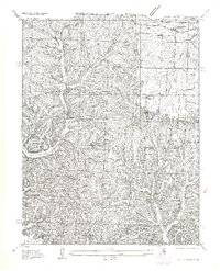
1957 Map of Rocky Mount
USGS Topo · Published 1957About this map
The shoreline of Lake of the Ozarks reaches into the southern half of this area, defining the landscape where Bogue Bay and various inlets meet the rugged Missouri interior. Along the northern edge, the Chicago Rock Island and Pacific railroad corridor serves the community of Barnett Sta, while the State Highway No 52 provides the primary overland route through the region. This survey captures a rural landscape where industry and education are closely tied to the land, evidenced by the Stover Coal Bank and a network of local institutions like the Roufon School and Laurel Ridge School. The terrain is characterized by the prominent Morgan Ridge and a complex drainage system including Indian Creek and South Fork Morgan Creek, illustrating the intersection of natural topography and the development of the Rocky Mount PO vicinity.
Find a feature on this map
26 named features on this map. Tap any name to fly to it.
Don’t see what you’re looking for? This feature index may not catch every label — zoom into the map to look around manually.
Map Details
Editions of this 1957 Rocky Mount Map
This is the sole edition of this map. No revisions or reprints were ever made.
Other maps of this area

1888 · Versailles
USGS Topo · 1:125,000

1893 · Versailles
USGS Topo · 1:125,000

1904 · Eldon
USGS Topo · 1:62,500

1904 · Gravois Mills
USGS Topo · 1:62,500

1932 · Versailles No 4
USGS Topo · 1:48,000

1934 · Purvis
USGS Topo · 1:24,000

1934 · Lake Ozark
USGS Topo · 1:24,000

1934 · Bagnell
USGS Topo · 1:24,000

1935 · Gravois Mills
USGS Topo · 1:24,000

1935 · Rocky Mount
USGS Topo · 1:24,000