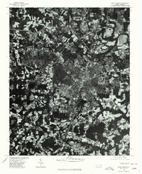
1975 Map of Rocky Mount
USGS Topo · Published 1978About this map
Rocky Mount serves as the central hub of this mid-1970s orthophotoquad, where the city's dense urban grid is visible against the surrounding agricultural lands of Nash and Edgecombe counties. The aerial photography, captured in April 1975, provides a literal view of the landscape rather than a traditional topographic illustration, revealing the exact patterns of development, forest stands, and cleared fields at the time. To the north, the smaller settlement of Battleboro is distinct, while Sharpsburg lies at the southern edge of the survey area. This photographic record, produced in cooperation with the Soil Conservation Service, emphasizes the transition between the established city core and the sprawling rural outskirts, capturing the state of the North Carolina coastal plain just before the final decades of the twentieth century.
Find a feature on this map
3 named features on this map. Tap any name to fly to it.
Don’t see what you’re looking for? This feature index may not catch every label — zoom into the map to look around manually.
Map Details
Editions of this 1975 Rocky Mount Map
This is the sole edition of this map. No revisions or reprints were ever made.
Other maps of this area

1902 · Rocky Mount
USGS Topo · 1:62,500

1902 · Tarboro
USGS Topo · 1:62,500

1903 · Tarboro
USGS Topo · 1:62,500

1904 · Rocky Mount
USGS Topo · 1:62,500

1953 · Norfolk
USGS Topo · 1:250,000

1953 · Rocky Mount
USGS Topo · 1:250,000

1954 · Rocky Mount
USGS Topo · 1:250,000

1961 · Whitakers
USGS Topo · 1:24,000

1963 · Red Oak
USGS Topo · 1:24,000

1963 · Drake
USGS Topo · 1:24,000